Image:Marcel.JPG
From Wikimarcellus
(Difference between revisions)
Marcel.JPG (27KB, MIME type: image/jpeg)
| Revision as of 19:38, 31 October 2010 Tcopley (Talk | contribs) (Map showing extent of the Marcellus shale formation. Map courtesy of [http://www.rigzone.com// Rigzone]) ← Previous diff |
Current revision Tcopley (Talk | contribs) (Map showing extent of the Marcellus shale formation. Map courtesy of [http://www.rigzone.com// Rigzone]) |
Current revision
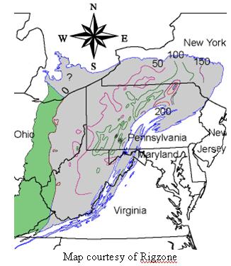
Map showing extent of the Marcellus shale formation. Map courtesy of Rigzone
File history
Legend: (cur) = this is the current file, (del) = delete
this old version, (rev) = revert to this old version.
Click on date to see the file uploaded on that date.
- (del) (cur) 19:38, 31 October 2010 . . Tcopley (Talk) . . 326x374 (27637 bytes) (Map showing extent of the Marcellus shale formation. Map courtesy of [http://www.rigzone.com// Rigzone])
- Edit this file using an external applicationSee the setup instructions for more information.
Links
The following pages link to this file:

